Earthquake
Earthquakes are sudden releases of energy from Earth’s crust that create seismic waves, typically occurring along fault lines. These geological events are classified into five main types: tectonic, volcanic, collapse, explosion, and reservoir-induced earthquakes. Understanding earthquake mechanics, measurement scales (Richter and Mercalli), and global distribution patterns is essential for comprehending their impact on human society and infrastructure. This comprehensive guide explores earthquake science, from crustal dynamics to safety preparedness.
An earthquake can be defined as the shaking or trembling of the Earth’s surface, primarily triggered by the sudden release of energy that generates vibrational waves propagating in every direction.
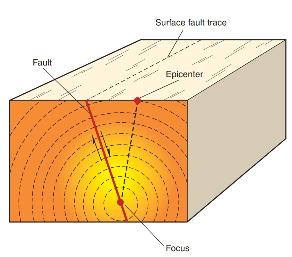
This energy discharge takes place along a fault line, which refers to a distinct fracture within the Earth’s crustal rocks. The rocks positioned along either side of the fault typically exert opposing movements. Due to the compression from the overlying strata, frictional resistance temporarily binds the rock masses together. Nevertheless, the inherent tendency of these rocks to shift in opposite directions eventually exceeds the frictional force, leading to a sudden slippage. This abrupt displacement causes the accumulated elastic energy to be released, generating seismic waves that radiate outward in all directions.

The precise location beneath the Earth’s surface where this energy emission originates is termed the focus, also known as the hypocentre. These seismic waves, upon emanation, ascend toward the surface. The point on the Earth’s exterior that lies vertically above the focus is known as the epicentre. This is the primary location to encounter the seismic waves, as it is positioned directly above the origin point of the earthquake.
Types of Earthquakes
Tectonic Earthquakes: These arise due to the horizontal displacement of crustal rocks along a fault plane. Such movement introduces a significant imbalance within the crustal framework, triggering seismic activity of varying intensity. The magnitude of these events is determined by the extent and character of the rock strata dislocation.
Volcanic Earthquakes: Volcanic phenomena are regarded as a fundamental catalyst of seismic disturbances. In fact, the relationship between volcanism and seismicity is so intricately connected that one frequently acts as both the cause and consequence of the other. Each volcanic eruption typically coincides with an earthquake, and certain intense seismic events may even induce volcanic eruptions. The pressurized release of volcanic gases, attempting to escape upward, forcefully exerts pressure on the crustal base, resulting in vigorous surface tremors. The severity of such tremors is directly influenced by the intensity of the volcanic explosion.
Collapse Earthquakes: In regions marked by extensive mining operations, the collapse of subterranean mine roofs may result in localized ground vibrations. These tremors, though generally minor in scale, are considered notable manifestations of seismic activity induced by human intervention.
Explosion Earthquakes: The detonation of chemical or nuclear explosives can also initiate ground vibrations. Such events, categorized under explosion-induced earthquakes, result from sudden energy release due to man-made detonations.
Reservoir-Induced Earthquakes: Seismic disturbances occurring in proximity to large artificial reservoirs are designated as reservoir-induced earthquakes. These are attributed to the immense pressure exerted by accumulated water masses, which can destabilize underlying rock formations.
These classifications also correspond to the principal causes of earthquakes, wherein categories one and two exemplify natural phenomena, while categories three, four, and five represent anthropogenic or human-generated causes of seismic activity.
Seismic Waves
The vibrations produced during an earthquake are termed seismic waves or earthquake waves. These waves are detected and recorded using a scientific instrument known as a seismograph or seismometer. For a more comprehensive understanding of seismic wave behavior, refer to the section addressing the Interior of the Earth.
Depth of Earthquakes
The depth at which an earthquake originates, referred to as the focus depth, plays a crucial role in determining the characteristics of seismic waves and the extent of damage caused. Earthquakes are classified into three types based on focal depth: deep-focus (ranging from 300 to 700 km), intermediate-focus (60 to 300 km), and shallow-focus (less than 60 km). Deep-focus earthquakes tend to be less destructive, as the amplitude of the waves diminishes significantly before reaching the surface. In contrast, shallow-focus earthquakes are more frequent and highly destructive due to their proximity to the Earth’s surface.
Measurement of Earthquakes
Seismic events are evaluated on the basis of either the magnitude or the intensity of the shock they produce.
Magnitude Scale
Magnitude refers to the total energy released during an earthquake and is determined through the quantitative assessment of seismic wave size. The most widely recognized magnitude scale is the Richter Scale. Developed in 1935 by Charles F. Richter, it provides a mathematical framework for comparing earthquake sizes. The Richter magnitude is calculated using the logarithm of the amplitude of waves recorded by a seismograph. Due to its logarithmic structure, each whole-number increment on this scale signifies a tenfold increase in measured wave amplitude. Furthermore, in terms of energy release, each unit rise on the scale corresponds to approximately 31 times more energy than the preceding value.
Intensity Scale
The intensity of an earthquake denotes the observable effects on human life, property, and natural surroundings. It is qualitatively measured, and its value at a given location is influenced by several important factors, including:
• the total energy discharged during the event,
• the distance from the epicentre,
• the type of geological materials present and their level of compaction.
The Mercalli Intensity Scale is a commonly used instrument for assessing earthquake intensity. It evaluates the impact of seismic activity on the Earth’s surface, people, natural features, and constructed structures, with values ranging from I (indicating “not felt”) to XII (representing “total destruction”). This scale is subjective, relying on observational data collected from individuals who experienced the quake. Each location is assigned an intensity value based on these firsthand reports.
Distribution of Earthquakes
The majority of global earthquakes are concentrated in the following notable zones:
• regions containing young fold mountain systems,
• areas marked by faulting and fracturing of the Earth’s crust,
• zones forming the boundaries between continental and oceanic margins,
• regions characterized by active volcanic activity, and
• locations aligned with various tectonic plate boundaries.
Seismic Belts of the World
The primary seismic zones across the globe are categorized as follows:
Circum-Pacific Belt:
This belt encompasses the coastal margins of North America, South America, and Eastern Asia. These regions constitute the eastern and western peripheries of the Pacific Ocean, collectively accounting for approximately 65 percent of the world’s total seismic activity.
The western margins are exemplified by the Rocky Mountains and the Andes mountain chains, both of which represent zones of convergent plate boundaries, where the Pacific Oceanic Plate is being subducted beneath the American continental plates.
The eastern margins are marked by island arcs such as Kamchatka, Sakhalin, Japan, and the Philippines. Earthquake occurrences in these zones result from the collision between the Pacific Plate and the Asiatic Plate, accompanied by intense volcanic activity. Notably, Japan alone records approximately 1,500 seismic tremors each year.

Mid-Continental Belt:
This belt spans the Alpine mountain system and its extensions across Europe, the Mediterranean region, Northern Africa, Eastern Africa, and the Himalayan range.
The Mid-Continental Belt extends longitudinally from the Sulaiman and Kirthar ranges in the west, through the Himalayas in the north, and stretches to Myanmar in the east. It delineates a weakened structural zone comprising Fold Mountains, accounting for around 21 percent of the global seismic incidents.
Mid-Atlantic Ridge Belt:
This belt incorporates the Mid-Atlantic Ridge and numerous adjacent islands located along the ridge axis. It is characterized by moderate-intensity earthquakes resulting from the divergent movement of tectonic plates in opposing directions. The seafloor spreading process, coupled with fissure-type volcanic eruptions, generates consistent yet moderately intense seismic disturbances throughout this region.
Seismic Zones of India
The Indian subcontinent is significantly susceptible to a range of natural disasters, among which earthquakes represent one of the most destructive and impactful hazards, capable of causing substantial loss to human life and infrastructure. A serious seismic threat exists in India, with approximately 59% of the nation’s geographical expanse exposed to seismic activity of varying intensities, including areas such as the national capital.

The geological diversity across various parts of the country indicates that the probability and severity of seismic events differ from region to region. Consequently, there is a critical need for a seismic zoning map to ensure that infrastructure development—including buildings and other civil structures—is carried out in accordance with the potential ground motion levels specific to each location. The existing seismic zone classification segments the country into four zones: Zone II, Zone III, Zone IV, and Zone V.
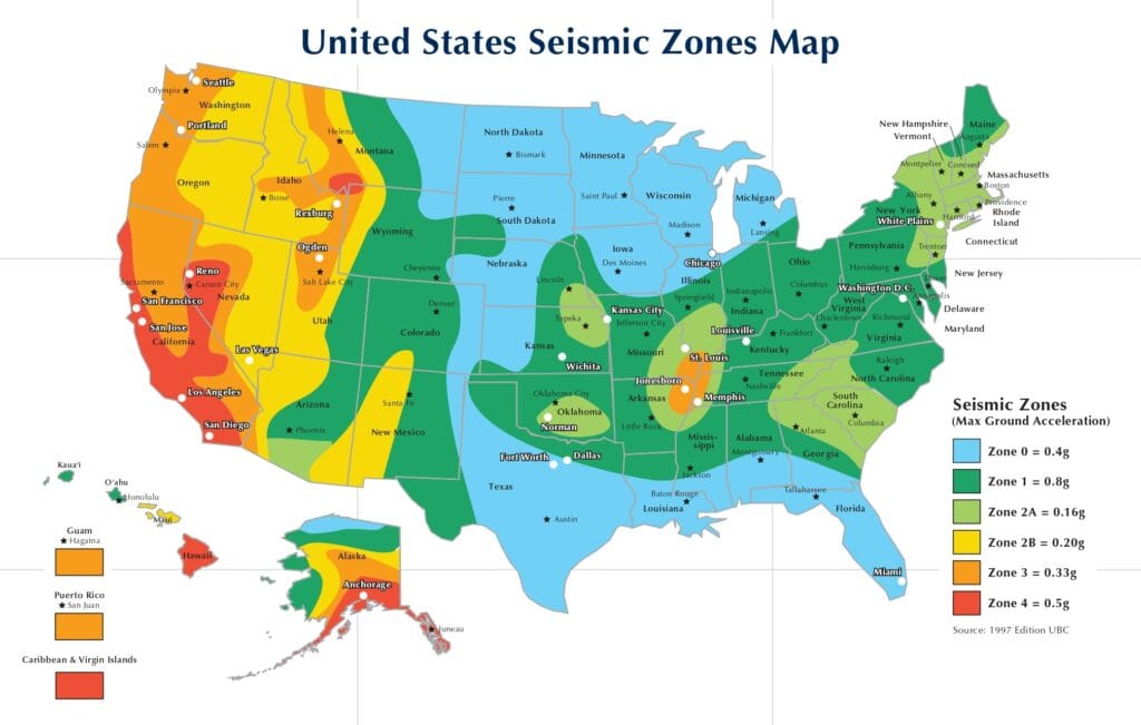
Seismic Zones of USA

Effects of Earthquakes
The direct and indirect consequences of an earthquake encompass a broad range of significant physical and socio-economic impacts:
Deformed Ground Surface: Seismic vibrations resulting from earthquake tremors lead to substantial alterations in the ground surface. These changes arise due to the uplift and subsidence of terrain, as well as fault-related dislocations. Floodplains composed of alluvial deposits may experience extensive fracturing across multiple locations.
Damage to Man-Made Structures: A wide array of human-engineered structures, including buildings, roads, railways, industrial complexes, dams, and bridges, are often subjected to severe structural failures during seismic events.
Damage to Towns and Cities: Urban centers endure the most profound impact, owing to their dense populations and concentrated infrastructure. The forceful ground motion can result in the collapse of large buildings, leaving residents buried under debris. In addition, water distribution systems are frequently disrupted due to damage to underground pipelines.
Loss of Human and Animal Life: The destructive magnitude of an earthquake is often assessed by the extent of casualties and property damage it causes. For instance, the 2001 Bhuj Earthquake in India, registering 8.1 on the Richter Scale, resulted in over 100,000 human fatalities, illustrating the devastating potential of high-magnitude events.
Devastating Fires: Intense seismic shocks can lead to widespread fires in residential areas, industrial zones, and mining sites. These are typically triggered by ruptured gas lines, exposed electrical wiring, disturbed furnaces, or malfunctioning electrical and fire-related appliances.
Landslides: In hilly and mountainous terrains, seismic vibrations often destabilize loose geological materials, initiating landslides. These movements can obliterate settlements, damage transportation networks, and disrupt communication systems.
Flash Floods: High-magnitude seismic events may cause dam failures, resulting in sudden and destructive flash floods. Additionally, river channels can become blocked by debris, causing water accumulation and altering river courses, sometimes permanently.
Tsunamis: When seismic energy propagates through oceanic waters, it gives rise to gigantic sea waves known as tsunamis. These waves can inflict catastrophic loss of life and infrastructure in coastal regions, often striking with minimal warning.
Earthquake Key Facts
- Global Annual Occurrence: Around 1 million earthquakes per year
- Major Seismic Belt: Circum-Pacific (Ring of Fire) – accounts for 65% of earthquake activity
- Most Active Country: Japan (about 1,500 tremors annually)
- Richter Scale: Logarithmic – each unit represents 10 times more amplitude
- Depth Categories:
- Shallow: less than 60 km
- Intermediate: 60–300 km
- Deep: 300–700 km
- India Risk: 59% of the landmass is exposed to seismic activity
