Mountain
Mountains are elevated landforms created through various geological processes over millions of years. There are four primary types of mountains based on their formation: fold mountains (formed by tectonic plate collision), block mountains (created by faulting), volcanic mountains (built from accumulated volcanic material), and residual mountains (formed through erosion). The most recent mountain-building episode, the Alpine orogeny, began 30 million years ago and created today’s highest peaks including the Himalayas, Alps, Andes, and Rockies.

What is the Definition of a Mountain? | Mountain Formation Basics
Since the inception of geological history, no fewer than nine distinct orogenic or mountain-forming episodes have reshaped the Earth’s crust through extensive folding and faulting. Some of these significant events transpired during the Precambrian era, approximately between 600 and 3,500 million years ago. Among the more recent orogenic phases are the Caledonian, Hercynian, and Alpine movements. The Caledonian orogeny, occurring around 320 million years ago, was responsible for uplifting the mountain systems of Scandinavia and Scotland, with geological extensions evident in North America. These ancient mountain systems have undergone substantial erosional processes over time and no longer reflect their original, prominent structural characteristics.
Subsequently, during the Hercynian orogeny, which occurred nearly 240 million years ago, mountain ranges such as the Ural Mountains, Pennines, Welsh Highlands of Britain, the Harz Mountains in Germany, and the Appalachians of North America were formed. These ranges, too, have experienced prolonged denudation, leading to considerable reduction in their elevation and topographic distinction due to continuous geomorphic activities.
The most recent and geologically crucial orogenic phase, known as the Alpine orogeny, commenced approximately 30 million years ago. This event gave rise to young fold mountain ranges on an immense scale. As the latest additions to Earth’s mountainous landscape, these ranges—including the Alps, Himalayas, Andes, and Rockies—stand as the most elevated, imposing, and notable. Some of their peaks ascend to altitudes of several miles, representing the most striking expressions of recent tectonic activity.
4 Main Types of Mountains: Classification and Formation
Mountains can be systematically classified into four primary categories based on their mode of formation:
Fold Mountains: Formation Through Tectonic Collision

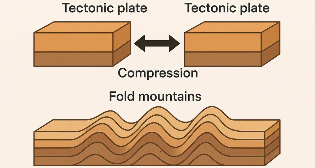
Among all types, fold mountains are the most extensively distributed and significant in geological terms. They are the result of large-scale tectonic processes that generate stress within the Earth’s crust. These stresses may arise from various fundamental geological phenomena, including:
An increase in the load exerted by overlying rock strata,
Mantle flow dynamics,
Magmatic intrusions penetrating into the crust, or
Thermal expansion or contraction occurring in specific zones of the Earth.
When these crucial stresses are activated, the affected rock layers are exposed to compressional forces, leading to the development of wrinkles or folds along structurally weakened zones. This deformation process induces a shortening of the Earth’s crust, transforming what was once a relatively level surface into a series of undulating wave-like structures.
The upward-arching folds in the rock strata are known as anticlines, whereas the downward trough-like folds are referred to as synclines. Owing to the complexity and intensity of compressional stresses, these folds may evolve into highly intricate structural forms. When the crest of a fold is displaced excessively, it results in the formation of an overfold. If the pressure intensifies further, this may transform into a recumbent fold, where the axis becomes nearly horizontal. Under extreme deformation, fractures may develop within the Earth’s crust, causing the upper segment of a recumbent fold to shift forward over the lower portion along a thrust plane, leading to the creation of an overthrust fold. The overriding mass in this structural feature is termed a nappe.
Because the rock layers have been uplifted to tremendous altitudes, often measurable in miles, fold mountains are frequently referred to as mountains of elevation. These mountains are also closely linked with volcanic activity. A considerable number of active volcanoes are concentrated in fold mountain systems, particularly within the Circum-Pacific Belt. Furthermore, fold mountains are notable for their abundant mineral deposits, including tin, copper, gold, and petroleum, making them economically significant geological formations.
Characteristics
- Fold mountains represent the youngest category of mountains present on the Earth’s surface.
- These young fold mountain ranges are home to the tallest elevations on the planet, including the highest summits. A notable instance is Mount Everest, which rises to a height of 8848 meters.
- The formation of fold mountains is attributed to the bending of sedimentary rock layers, which originated through the accumulation and compaction of sediments primarily within marine environments.
- These sedimentary formations were laid down in shallow marine basins, where prolonged subsidence and uninterrupted sedimentation allowed for the development of thick stratified layers.
- The linear extension of fold mountain chains far exceeds their transverse width. For instance, the Himalayan range spans approximately 2400 kilometers along the east-west axis, whereas its north-south breadth is limited to nearly 400 kilometers. This suggests that such mountain systems must have emerged within elongated, narrow, and shallow seaways.
- In general, fold mountains exhibit a distinct arc-like configuration, characterized by a concave slope on one side and a convex slope on the opposite side.
- These mountains are commonly situated along the continental margins that are adjacent to oceans, as exemplified by the Andes and the Rocky Mountains. Considering the historical presence of the Tethys Sea, the Himalayas may also be classified as forming along a continental margin.
- The geographical orientation of fold mountains predominantly falls into two alignments: the north-south trend is exemplified by the Rockies and the Andes, while the west-east trend includes the Himalayas and the Alps.
Human Activity Surrounding Fold Mountains
Winter recreational sports, particularly skiing, are widely practiced at mountain resorts located in fold mountain regions.
Mountaineering and hiking are popular during the summer season, attracting numerous outdoor enthusiasts.
Agricultural activities are predominantly carried out on south-facing slopes, where cultivation includes cereal crops, sugar beet, vineyards, and various fruit varieties.
Forestry operations are common, especially involving coniferous tree species, which are harvested for fuelwood and construction materials.
Transportation infrastructure, such as roads and railway lines, is strategically developed by following the natural valleys that cut through fold mountains.
Hydroelectric power (HEP) generation is facilitated by the steep gradients and the availability of glacial meltwater, making these regions highly suitable for energy production. Notably, in Switzerland, hydroelectric energy accounts for approximately 60 percent of the nation’s total electricity supply.
Block Mountains: Fault-Created Mountain Ranges

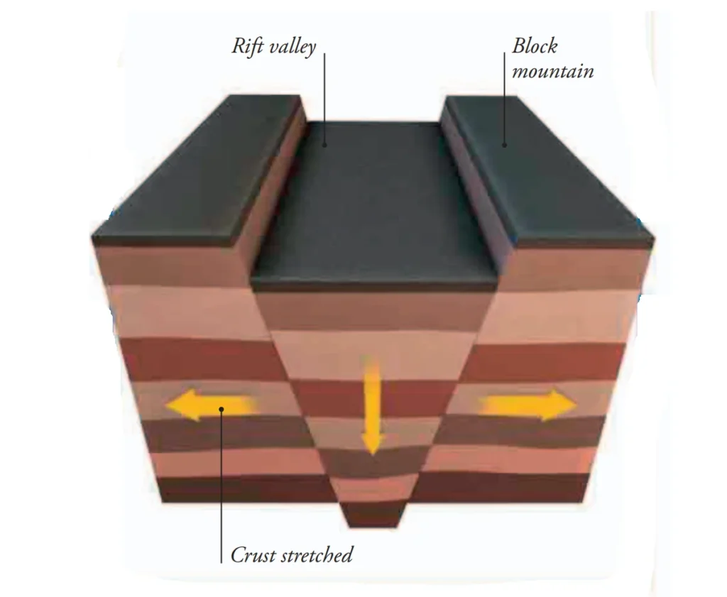
Folding occurs when the Earth’s crust undergoes bending, whereas faulting results when the crust fractures. Faulting can be triggered by either tensional or compressional forces, which act to elongate or contract sections of the crust, leading to either subsidence or uplift of distinct land segments. Tectonic activity generates tensional stress, which attempts to pull apart the crustal layers, forming fault lines.
If the block of crust situated between two parallel faults either remains stationary or is uplifted, while the adjacent landmasses sink, this elevated section becomes known as a horst, or more commonly, a block mountain. The margins of such formations are sharply defined by steep fault scarps, and the summit typically appears relatively flat. Notable examples include the Hunsrück Mountains, and the Vosges and Black Forest ranges in the Rhineland.
Tensional forces can also lead to the subsidence of the central landmass situated between two adjacent fault blocks, resulting in the formation of a graben, commonly referred to as a rift valley, which is characterized by its steep-sided escarpments. One of the most notable examples of such a geological feature is the East African Rift Valley system, which extends approximately 3,000 miles, traversing from East Africa, through the Red Sea, and reaching as far as Syria.
On the other hand, compressional stresses generated by tectonic movements can give rise to a thrust fault or reverse fault, thereby inducing a shortening of the crustal structure. In such cases, a block of land may be either uplifted or depressed relative to its adjacent regions. Although rift valleys can occasionally result from compression, such features—along with large-scale block mountains—are primarily the consequence of tensional forces acting upon the Earth’s crust.
Volcanic Mountains: Formation Through Eruption and Accumulation
These mountains are formed through the accumulation of materials expelled from fissures in the Earth’s crust. The ejected substances consist of molten lava, volcanic bombs, cinders, ash, fine dust, and occasionally, liquid mud. These materials are deposited around the volcanic vent in successive strata, gradually constructing the typical conical structure known as a volcanic cone.

Volcanic mountains are frequently referred to as mountains of accumulation due to their constructive origin. They are especially common along the Circum-Pacific Belt, a geologically active region. Prominent examples include Mount Fuji in Japan, Mount Mayon in the Philippines, Mount Merapi in Sumatra, Mount Agung in Bali, and Mount Cotopaxi in Ecuador.
Residual Mountains: Erosion-Formed Highland Features
Residual mountains are formed as a result of denudational processes. When the overall elevation of a landmass is lowered by various agents of denudation, certain highly resistant rock masses may persist and stand above the surrounding landscape, forming residual uplands. A notable example is Mount Monadnock in the United States.
In some cases, residual mountains can also develop from plateau regions that have undergone deep dissection by river systems, carving the surface into a pattern of hills and valleys. These mountains are characterized by uniform elevations, where the ridges and summits tend to exhibit similar heights, reflecting the original plateau surface before erosion.
FAQs
What are the 4 main types of mountains?
The four main types of mountains are: 1) Fold mountains (formed by tectonic plate collision), 2) Block mountains (created by faulting), 3) Volcanic mountains (built from volcanic material accumulation), and 4) Residual mountains (formed through erosion processes).
How are fold mountains formed?
Fold mountains form when tectonic plates collide, creating compressional forces that cause rock layers to buckle and fold. This process creates anticlines (upward folds) and synclines (downward folds), resulting in some of the world’s highest mountain ranges like the Himalayas and Alps.
What is the Alpine orogeny?
The Alpine orogeny is the most recent mountain-building episode that began approximately 30 million years ago. It created young fold mountain ranges including the Alps, Himalayas, Andes, and Rocky Mountains, which contain the world’s highest peaks.
What are volcanic mountains?
Volcanic mountains are formed through the accumulation of materials expelled from Earth’s crust, including molten lava, volcanic bombs, cinders, ash, and dust. These materials build up around volcanic vents to create typical conical structures.
How do block mountains differ from fold mountains?
Block mountains form through faulting when Earth’s crust fractures, creating uplifted blocks called horsts with steep fault scarps. Unlike fold mountains that result from bending, block mountains have relatively flat summits and sharp, well-defined margins.
