CHAPTER:1 Earth and It’s Atmosphere Part 2

Meteorology Today

Table of Contents

Vertical Structure of the Atmosphere

Air molecules (as well as everything else) are held near Earth by gravity. This strong, invisible force pulling down on the air squeezes (compresses) air molecules closer together, which causes their number in a given volume to increase. The more air above a level, the greater the squeezing effect or compression.

As air density is the number of air molecules in a given volume, therefore air density is greatest at surface and decreases upward. The density of air (or any substance) is determined by the masses of atoms and molecules and the amount of space between them.

As air near the surface is compressed, so air density decreases rapidly at first, then more slowly as we move up from the surface.

The weight of all the air around Earth is a stag gering 5600 trillion tons, or roughly 5.08X10¹⁸ kg. The weight of the air molecules acts as a force upon Earth. The amount of force exerted over an area of surface is called atmospheric pressure or, simply, air pressure. As the number of air molecules decreases with height, so atmospheric pressure decreases with increasing height. Like density, air pressure decreases rapidly at first, more slowly at higher levels.

At sea level, the average or standard value for atmospheric pressure is

1013.25b = 1013.25 hpa = 29.92 in Hg

At an altitude of 50km, the air pressure is 1mb, which means 99.9% of all the air molecules are below 50 km.

Layers of the Atmosphere

We know both air pressure and density decrease with height- rapidly at first, then more slowly. But air temperature has a more complicated vertical structure.

Air temperature normally decreases from Earth’s surface up to an altitude of about 11 km, which is nearly 36,000 ft, or 7 mi. This decrease in air temperature with increasing height is due primarily to the fact  that sunlight warms Earth’s surface, and the surface, in turn, warms the air above it.

The rate at which the air temperature decreases with height is called the temperature lapse rate. The average (or standard) lapse rate in this region of the lower atmosphere is about 6.50C for every 1000 m or about 3.60F for every 1000-ft increase in altitude. (Keep in mind that these values are only averages)

If air becomes colder more quickly with height, then the lapse rate steepens and when the air cools slowly with increasing height the lapse rate is less. Occasionally  the  air  temperature  increases  with  height,  producing  a  condition  called Temperature inversion. The lapse rate fluctuates, varying from day to day, season to season, and place to place.

When the temperature decreases with height, the lapse rate is positive (in Troposphere and Mesosphere).

When the temperature increases with height, the lapse rate is negative (in Stratosphere and Thermosphere). This region of circulating air extending upward from Earth’s surface to where the air stops becoming colder with height is called the troposphere— from the Greek tropein, meaning “to turn” or “to change.”

Above 11 km the air temperature normally stops decreasing with height. Here, the lapse rate is zero. This region, where, on average, the air temperature remains constant with height, is referred to as an isothermal (equal temperature) zone.

The boundary separating the troposphere from the stratosphere is called the tropopause. The height of the tropopause varies. It is normally found at higher elevations over equatorial regions, and it decreases in elevation as we travel poleward. The tropopause is higher in summer and lower in winter at all latitudes.

In stratosphere the air temperature begins to increase with height, producing a temperature inversion condition. This inversion restricts the air of the troposphere to spread out vertically. the air temperature is increasing with height, the air at an altitude of 30 km (about 100,000 feet or 19 mi) is extremely cold, averaging less than -460C (-510F).

The reason behind this increase in temperature in stratosphere is the absorption of UV rays by ozone. Above the stratosphere is the mesosphere. The air is extremely thin here and atmospheric pressure is quite low. With a temperature of -90°C, top of the mesosphere is coldest place of our atmosphere. The hot layer above mesosphere is the thermosphere. Here the oxygen molecules absorb the energetic solar rays, warming the air. Although the temperature exceeds 5000C in thermosphere, but a person shielded from the sun would not necessarily feel hot because there are very few molecules are present in this region to bump against something.

Above thermosphere many of the lighter, faster-moving molecules travelling in the right direction escape the earth’s gravitational pull. The region where atom and molecules shoot off into space is called Exosphere. Below the thermosphere the composition of the atmosphere is uniform (78% nitrogen and 21% oxygen). This lower well mixed region is called homosphere.In thermosphere due to very less number of air molecules stratification of air molecules (heavier atoms settle to the bottom and lighter float at the top). This stratified layer is called heterosphere.

Ionosphere

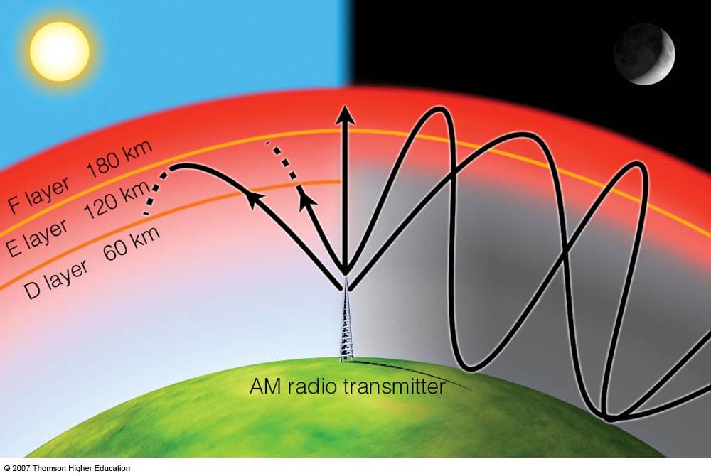
Ionosphere is an electrified region in the upper atmosphere, where large concentration of ions and free electrons exist. The ionosphere starts about 60 km above the earth’s surface. So major portion of the ionosphere is in the thermosphere. The ionosphere plays an important role in radio communication. The lower D region/layer absorbs the AM radio waves, thereby weakening the same. During night the D regions disappears and AM radio waves are able to penetrate higher into the ionosphere (E & F regions). After reflecting from this AM waves are able to travel for many hundred kilometers at night. Layers of the atmosphere based on temperature, composition and electrical properties are given in
Important elements of climatology

  1. air temperature—the degree of hotness or coldness of the air
  2. air pressure—the force of the air above an area
  3. humidity—a measure of the amount of water vapor in the air
  4. clouds—visible masses of tiny water droplets and/or ice crystals that are above Earth’s surface
  5. precipitation—any form of water, either liquid or solid (rain or snow), that falls from clouds and reaches the ground
  6. visibility—the greatest distance one can see
  7. wind—the horizontal movement of air
READ ALSO  CHAPTER:1 Earth and It's Atmosphere Part 1

Leave a Reply

CSIR NET Exam: EARTH, ATMOSPHERIC, OCEAN AND PLANETARY SCIENCES

Exam Pattern: EARTH, ATMOSPHERIC, OCEAN AND PLANETARY SCIENCES 

 PART APART BPART CTOTAL
Total questions205080150
Max No. of Questions to attempt15352575
Marks for each correct answer224200
Marks for each incorrect answer (Negative marking for part A & B is @ 25%, and part C is @ 33%)0.50.51.32

The candidate is required to answer a maximum of 15, 35, and 25 questions from Part-A, Part-B, and Part-C, respectively. If more than the required number of questions are answered, only the first 15, 35, and 25 questions in Part A, Part B, and Part C, respectively, will be taken up for evaluation.

Below each question in Part A, Part B, and Part C, four alternatives or responses are given. Only one of these alternatives is the “correct” option to the question. The candidate has to find, for each question, the correct or the best answer.

Syllabus

EARTH, ATMOSPHERIC, OCEAN AND PLANETARY SCIENCES

PAPER I (PART B)

  1. The Earth and the Solar System

    • Milky Way and the solar system.
    • Modern theories on the origin of the Earth and planetary bodies.
    • Earth’s orbital parameters, Kepler’s laws of planetary motion.
    • Geological Time Scale; space and time scales of processes in the solid Earth, atmosphere, and oceans.
    • Radioactive isotopes and their applications.
    • Meteorites: chemical composition and primary differentiation of the Earth.
    • Basic principles of stratigraphy.
    • Theories about the origin of life and fossil records.
    • Earth’s gravity, magnetic fields, and thermal structure: Geoid and spheroid concepts; Isostasy.
  2. Earth Materials, Surface Features, and Processes

    • Gross composition and physical properties of important minerals and rocks.
    • Properties and processes responsible for mineral concentrations.
    • Distribution of rocks and minerals in Earth’s units and India.
    • Physiography of the Earth; weathering, erosion, and soil formation.
    • Energy balance of Earth’s surface processes.
    • Physiographic features and river basins in India.
  3. Interior of the Earth, Deformation, and Tectonics

    • Basic concepts of seismology and Earth’s internal structure.
    • Physico-chemical and seismic properties of Earth’s interior.
    • Stress and strain concepts; rock deformation.
    • Folds, joints, and faults; causes and measurement of earthquakes.
    • Interplate and intraplate seismicity; paleomagnetism.
    • Sea-floor spreading and plate tectonics.
  4. Oceans and Atmosphere

    • Hypsography of continents and ocean floors: continental shelves, slopes, abyssal plains.
    • Physical and chemical properties of seawater; residence times of elements.
    • Ocean currents, waves, tides, thermohaline circulation, and conveyor belts.
    • Major water masses, biological productivity, and fluid motion.
    • Atmospheric structure and heat budget; greenhouse gases and global warming.
    • General circulation, monsoon systems, ENSO, cyclones, and local systems in India.
    • Marine and atmospheric pollution, ozone depletion.
  5. Environmental Earth Sciences

    • Properties of water and the hydrological cycle.
    • Energy resources: uses, degradation, alternatives, and management.
    • Ecology, biodiversity, and natural resource conservation.
    • Natural hazards and remote sensing applications.

PAPER I (PART C)

I. Geology

  1. Mineralogy and Petrology

    • Point group, space group, and lattice concepts.
    • Crystal field theory, mineralogical spectroscopy, and bonding in mineral structures.
    • Genesis, properties, and crystallization of magmas.
    • Metamorphic structures, textures, and thermobarometry.
    • Petrogenesis of Indian rock suites: Deccan Traps, charnockites, ophiolites, and more.
  2. Structural Geology and Geotectonics

    • Stress and strain analysis; Mohr circles.
    • Geometry and mechanics of folds, faults, and ductile shear zones.
    • Plate boundaries, mantle plumes, and Himalayan orogeny.
  3. Paleontology and Applications

    • Life origin theories, evolution models, and mass extinctions.
    • Applications of fossils in age determination, paleoecology, and paleogeography.
    • Micropaleontology in hydrocarbon exploration.
  4. Sedimentology and Stratigraphy

    • Classification of sediments and sedimentary rocks.
    • Sedimentary environments and basin evolution.
    • Stratigraphic principles, correlation methods, and sequence stratigraphy.
    • Phanerozoic stratigraphy of India.
  5. Marine Geology and Paleoceanography

    • Ocean floor morphology, ocean circulation, and thermohaline processes.
    • Factors influencing oceanic sediments and paleoceanographic reconstruction.
  6. Geochemistry

    • Atomic properties, periodic table, thermodynamics of reactions, and isotopes in geochronology.
    • Applications of stable isotopes in Earth processes.
  7. Economic Geology

    • Ore formation processes, mineral deposit studies, and petroleum geology.
    • Coal and unconventional energy resources.
  8. Precambrian Geology and Crustal Evolution

    • Evolution of Earth systems and Precambrian characteristics of India.
    • Precambrian–Cambrian boundary.
  9. Quaternary Geology

    • Quaternary stratigraphy, climate variability, and human evolution.
    • Dating methods and tectonic geomorphology.
  10. Applied Geology

  • Remote sensing and GIS.
  • Engineering properties of rocks; construction investigations.
  • Methods of mineral exploration and groundwater studies.

II. Physical Geography

  1. Geomorphology: Landform processes, DEM analysis, extraterrestrial geomorphology.
  2. Climatology: Radiation balance, wind systems, ENSO, and climate classification.
  3. Biogeography: Plant and animal associations, Indian biogeography, and conservation.
  4. Environmental Geography: Man-land relationships, hazards, and ecological balance.
  5. Geography of India: Physical geography, climatology, agriculture, and population characteristics.

III. Geophysics

  1. Signal Processing: Fourier transforms, filters, and signal analysis.
  2. Field Theory: Newtonian potential, Green’s theorem, and seismic wave propagation.
  3. Numerical Analysis and Inversion: Least squares, optimization, and pattern recognition.
  4. Gravity and Magnetic Methods: Data interpretation and anomaly analysis.
  5. Seismic Methods: Ray theory, reflection/refraction techniques, seismic stratigraphy.
  6. Well Logging: Techniques for lithology, porosity, and fluid saturation interpretation.

(IV) METEOROLOGY

1) Climatology

  • Same as under Geography.

2) Physical Meteorology

  • Thermal Structure of the Atmosphere and Its Composition.
  • Radiation:
    • Basic laws – Rayleigh and Mie scattering, multiple scattering.
    • Radiation from the sun, solar constant, effect of clouds, surface and planetary albedo.
    • Emission and absorption of terrestrial radiation, radiation windows, radiative transfer, Greenhouse effect, net radiation budget.
  • Thermodynamics of Dry and Moist Air:
    • Specific gas constant, adiabatic and isentropic processes, entropy and enthalpy.
    • Moisture variables, virtual temperature, Clausius–Clapeyron equation.
    • Adiabatic processes of moist air, thermodynamic diagrams.
  • Hydrostatic Equilibrium:
    • Hydrostatic equation, variation of pressure with height, geopotential, standard atmosphere, altimetry.
  • Vertical Stability of the Atmosphere:
    • Dry and moist air parcel and slice methods, tropical convection.
  • Atmospheric Optics:
    • Visibility and optical phenomena – rainbows, haloes, corona, mirage, etc.

3) Atmospheric Electricity

  • Fair weather electric field in the atmosphere and potential gradients.
  • Ionization in the atmosphere, electrical fields in thunderstorms.
  • Theories of thunderstorm electrification, structure of lightning flash, mechanisms of earth-atmospheric charge balance, and the role of thunderstorms.

4) Cloud Physics

  • Cloud classification, condensation nuclei, growth of cloud drops and ice-crystals.
  • Precipitation mechanisms: Bergeron–Findeisen process, coalescence process.
  • Precipitation of warm and mixed clouds, artificial precipitation, hail suppression, fog and cloud dissipation.
  • Radar observation of clouds and precipitation:
    • Radar equation, rain drop spectra, radar echoes of hailstorms, tornadoes, hurricanes, and rainfall measurements.

5) Dynamic Meteorology

  • Basic Equations and Fundamental Forces:
    • Pressure, gravity, centripetal and Coriolis forces.
    • Continuity and momentum equations (Cartesian and spherical coordinates).
    • Scale analysis, inertial flow, geostrophic and gradient winds, thermal wind.
    • Divergence and vertical motion, Rossby, Richardson, Reynolds, and Froude numbers.
  • Atmospheric Turbulence:
    • Mixing length theory, planetary boundary layer equations, Ekman layer, eddy transport of heat, moisture, and momentum.
  • Linear Perturbation Theory:
    • Internal and external gravity waves, inertia waves, gravity waves, Rossby waves, wave motion in the tropics, barotropic and baroclinic instabilities.
  • Atmospheric Energetics:
    • Kinetic, potential, and internal energies; conversion into kinetic energy; available potential energy.

6) Numerical Weather Prediction (NWP)

  • Computational instability, filtering of sound and gravity waves.
  • Filtered forecast equations, barotropic and baroclinic models.
  • Objective analysis, data assimilation techniques, satellite applications in NWP.

7) General Circulation and Climate Modelling

  • Observed zonally symmetric circulations, meridional circulation models.
  • General circulation modelling principles: grid-point and spectral GCMs.
  • Climate variability phenomena: ENSO, QBO, MJO, etc.
  • Ocean-atmosphere coupled models.

8) Synoptic Meteorology

  • Weather observations and transmission, synoptic charts.
  • Synoptic weather forecasting, prediction of weather elements, and hazardous weather phenomena.
  • Tropical Meteorology:
    • ITCZ, monsoons, tropical cyclones, jet streams.
  • Extra-Tropical Features:
    • Jet streams, extratropical cyclones, anticyclones.
  • Air masses and fronts: sources, classification, frontogenesis, and associated weather.

9) Aviation Meteorology

  • Meteorological role in aviation, weather hazards during takeoff, cruising, and landing.
  • In-flight hazards: icing, turbulence, visibility issues, gusts, wind shear, thunderstorms.

10) Satellite Meteorology

  • Polar orbiting and geostationary satellites.
  • Applications in identifying synoptic systems, cyclones, temperature estimation, rainfall prediction, and temperature/humidity soundings.

(V) OCEAN SCIENCES

1) Physical Oceanography

  • T-S diagrams, mixing processes, characteristics of water masses.
  • Wind-generated waves, shallow and deep-water wave dynamics.
  • Coastal processes: wave reflection, refraction, diffraction, littoral currents, rip currents, tsunami, and more.
  • Ocean Circulation:
    • Global conveyor belt circulation, Ekman’s theory, upwelling processes.

2) Chemical Oceanography

  • Composition of seawater, chemical exchanges, and classification of elements.
  • Element chemistry under special conditions (estuaries, vents, etc.).
  • Carbonate chemistry, biological pumps, and sedimentary deposit factors.

3) Geological Oceanography

  • Topics as listed under “Marine Geology & Paleoceanography.”

4) Biological Oceanography

  • Classification of marine environments and organisms.
  • Primary and secondary production, factors affecting biodiversity.
  • Human impacts on marine communities and climate change effects.


How Study Hub Can Help You Prepare for the Earth, Atmospheric, Ocean, and Planetary Sciences Syllabus

Preparing for the extensive and demanding syllabus of Earth, Atmospheric, Ocean, and Planetary Sciences (702) requires a strategic approach and access to comprehensive study resources. Study Hub (accessible at studyhub.net.in) offers unparalleled support to help candidates excel in this challenging domain. Here’s how Study Hub can guide your preparation:


Comprehensive Coverage of Topics

At Study Hub, we provide in-depth study materials, mock tests, and curated articles to help candidates grasp even the most complex topics. Our resources are designed to address every aspect of the syllabus, including:

  1. Meteorology: Understand critical concepts like the thermal structure of the atmosphere, radiative transfer, vertical stability, numerical weather prediction, general circulation and climate modelling, and the role of satellite meteorology in observing weather systems such as cyclones, monsoons, and thunderstorms.

  2. Ocean Sciences: Dive into topics such as physical oceanography, chemical oceanography, geological oceanography, and biological oceanography. Study Hub’s resources emphasize key aspects like upwelling processes, estuarine circulation, ocean eddies, Ekman theory, and global conveyor belt circulation—helping you understand the intricate processes of ocean systems.

  3. Atmospheric Dynamics and Energetics: Through articles, conceptual guides, and practice questions, candidates gain a strong grasp of fundamental equations, vorticity, geostrophic winds, Rossby waves, atmospheric turbulence, and barotropic and baroclinic instabilities.

  4. Planetary Sciences: Our expertly crafted content helps students explore planetary structures, processes, and phenomena with precision, complementing other topics under Earth Sciences for an interdisciplinary understanding.


Mock Tests and Evaluation Framework

We align our mock tests and sample papers with the pattern of the Earth Sciences examination:

  • Objective Analysis for Numerical Weather Prediction (NWP): Test your knowledge of filtered forecasting models and data assimilation techniques.
  • Synoptic Meteorology Practices: Work on real-world weather data and forecast exercises involving tropical cyclones, ITCZ systems, monsoon depressions, and jet streams.
  • Topic-specific tests ensure mastery in areas like atmospheric optics, biochemical nutrient cycling, and the impact of human activities on ecosystems.

Why Study Hub is the Perfect Partner for Your Earth Sciences Preparation

  1. Academic Rigor: Study Hub maintains an academic tone throughout its resources, ensuring in-depth coverage of essential keywords such as radiative budget, MJO (Madden-Julian Oscillation), Quasi-Biennial Oscillation (QBO), and ENSO phenomena.
  2. Focused on Practical Applications: Be it radar observations, wave refraction techniques, or the impact of anthropogenic inputs on marine biodiversity, we emphasize the practical relevance of each topic for better comprehension.
  3. Adaptive Materials: From simple T-S diagrams to advanced topics like geopotential variation and numerical baroclinic models, we tailor our resources to match both beginner and advanced levels of understanding.
Scroll to Top