Satpura Mobile Belt (SMB)
What is the Satpura Mobile Belt?
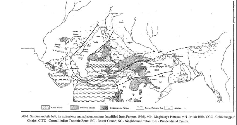
The Satpura Mobile Belt (SMB) is a very long east-west trending orogenic belt that traverses the northern part of Peninsular India. It divides the Indian shield into the northern Bundelkhand protocontinent and the southern Deccan protocontinent.
How is the Satpura Mobile Belt divided?
The belt is divided into four sectors along its strike from west to east:
- Aravalli craton with its Aravalli-Delhi orogen
- Central Indian Tectonic Zone (CITZ)
- Chhotanagpur Gneiss with North Singhbhum Orogen (NSO)
- Meghalaya Plateau of North-East India
What is the Central Indian Tectonic Zone (CITZ)?
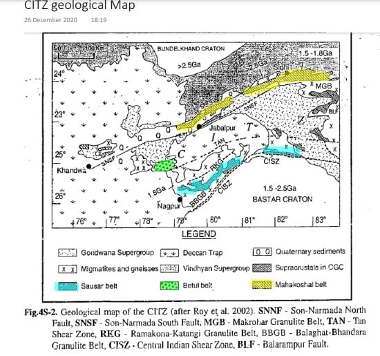
The CITZ is the most extensively studied sector of the SMB and is often considered synonymous with the Satpura Mobile Belt. It is bounded by:
- North: Son-Narmada North Fault (SNNF), which abuts against the Vindhyan basin south of Bundelkhand granite.
- South: Central Indian Shear Zone (CISZ), which abuts against the Bastar craton.
What are the main geological features of the Satpura Mobile Belt?
- Coverage: Mainly covered by Gondwana sediments, Deccan traps, and Quaternary alluvium.
- Composition: Consists mainly of gneisses, supracrustals, granites, and boudin-type granulites.
- Granulite Belts: Includes Makrohar belt (north), Ramakona Katangi (middle), and Balaghat-Bhandara (south).
- Supracrustal Belts: Includes Mahakaushal (north), Betul (center), and Sausar (south).
Where are the supracrustal belts located?
- Mahakoshal Supracrustal Belt: Located in the northern part of CITZ between the SNNF and SNSF (Son-Narmada South Fault).
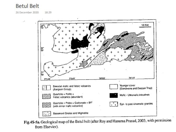
- Betul Supracrustal Belt: Located in the south between the Mahakoshal and Sausar belts, within gneisses dated at 1500 Ma. It is separated from the Mahakoshal belt by the Balarampur Fault and from the Sausar belt by the Tan Shear Zone. This belt is dissected by faults and covered by Gondwana sediments and Deccan Trap.
What is notable about the Betul belt?
- Mineralization: Pb-Zn mineralization is reported from the Betul belt.
- Geological Composition: Exposes Betul Supergroup, which consists of magnesian schists, garnet-staurolite-biotite-graphite schists, and calc-silicate rocks (Golighat Group).
How old is the Satpura Orogeny?
The age of the Satpura Orogeny is between 1.5 to 2 billion years ago (Ga).
Satpura mobile belt and its Extensions

N-S Cross section of Central Indian Tectonic Zone
| Region | Feature/Group | |
| Vindhyan and Bijawar Basins and Gneissic Slivers (e.g. Sidhi) (Bundelkhand craton) | ||
| Son-Narmada North Fault | C I T Z | |
| Mahakoshal Group | ||
| Son-Narmada South Fault | ||
| Makrohar Granulite Belt | ||
| Balrampur Fault | ||
| Betul Group | ||
| Tan Shear Zone | ||
| Ramakona-Katangi Granulite Belt | ||
| Sausar Group | ||
| Bhandara-Balaghat Granulite Belt | ||
| Central Indian Shear Zone | ||
| Sakoli and Chitpi Belts and Gneisses (Bastar craton) | ||
CITZ Geological Map Overview

This geological map of the Central Indian Tectonic Zone (CITZ) illustrates various geological features and formations across the Bundelkhand and Bastar cratons. Key elements include faults, shear zones, granulite belts, and distinct geological groups. Below is a detailed explanation of the map components:
Key Elements on the Map
- Faults and Shear Zones
- SNNF (Son-Narmada North Fault)
- SNSF (Son-Narmada South Fault)
- TAN (Tan Shear Zone)
- CISZ (Central Indian Shear Zone)
- BLF (Balrampur Fault)
- Granulite Belts
- MGB (Makrohar Granulite Belt)
- RKG (Ramakona-Katangi Granulite Belt)
- BBGB (Balaghat-Bhandara Granulite Belt)
- Geological Groups and Supergroups
- Gondwana Supergroup
- Vindhyan Supergroup
- Mahakoshal Group
- Sausar Group
- Betul Group
Craton Locations and Age Indicators
- Bundelkhand Craton
- Dominated by the 2.5 Ga (Giga annum) age group.
- Bastar Craton
- Includes regions with 1.5 – 2.5 Ga and 1.5 – 1.86 Ga age groups.
Legend Explanation
- Gondwana Supergroup: Represented by specific map symbols.
- Deccan Trap: Indicated in the geological map.
- Quaternary Sediments: Shown with specific patterns.
- Migmatites and Gneisses: Marked with unique symbols.
- Vindhyan Supergroup: Highlighted distinctly.
- Supracrustals in CGC: Noted with corresponding symbols.
- Mahakoshal Belt: Emphasized with its own symbols.
- Sausar Belt: Clearly indicated on the map.
Notable Regions
- Sidhi, Jabalpur, Nagpur, Khandwa, Betul
- Key locations marked to show their relation to various geological features and formations.
Lithostratigraphy of Mahakoshal Group (1800 Ma)
| Formation | Description | Other Nomenclature |
| Dudhamaniya Formation | Alternating sequence of BIF and phyllite | Parsoi Fm. |
| – – – – – – – Gradational Contact – – – – – – – | ||
| Parsoi Formation | Greywacke-argillite, carbonaceous phyllite, feldspathic quartzite and basal polymict conglomerate | Parsoi Fm. |
| – – – – – – – Faulted Contact/Unconformity – – – – – – – | ||
| Sleemanabad Formation | Pillowed basalt, manganiferous chert, BIF and ultramafic plugs | Chitrangi Fm. |
| Quartz arenite, stromatolitic carbonate, BIF and phyllite | Agori Fm. | |
| – – – – – – – Unconformity – – – – – – – | ||
| Sidhi gneiss and Dudhi granitoids with enclaves of supracrustal rocks | ||
- Quartz porphyry, albite granite, syenite, lamprophyre, dolerite, peridotite/dunite Granitoids: Found in Barambaba, Jhirgadandi, Madanmahal, Tamakhan.
- Fm = Formation
Betul Belt Geological Map

This geological map of the Betul Belt, as depicted by Roy and Hanuma Prasad (2003), illustrates various geological formations and rock types in the region.
Geological Units
- Bimodal Mafic and Felsic Volcanics (Baragon Group):
- Represented by: Diagonal lines with solid squares.
- Significance: Indicative of volcanic activity with both mafic (rich in magnesium and iron) and felsic (rich in silica) components.
- Quartzite + Pelite + Felsic Volcanics (Abundant):
- Represented by: Horizontal lines with dots.
- Significance: Quartzite and pelite formations along with abundant felsic volcanic rocks.
- Quartzite + Pelite + Carbonate + BIF (with minor mafic volcanic):
- Represented by: Checkerboard pattern.
- Significance: A mix of quartzite, pelite, carbonate rocks, and banded iron formations (BIF) with minor mafic volcanic intrusions.
- Basement Gneiss and Migmatite:
- Represented by: Stippled pattern.
- Significance: Ancient, highly metamorphosed rocks form the basement of the geological structure.
- Younger Cover (Gondwana and Deccan Trap):
- Represented by: Crosses.
- Significance: Covers from the Gondwana supercontinent period and Deccan Traps, indicative of younger geological formations overlaying older rocks.
- Mafic – Ultramafic Intrusives:
- Represented by: Solid black areas.
- Significance: Intrusive igneous rocks with high magnesium and iron content, typically denser and darker.
- Syn- to Post-Kinematic Granites:
- Represented by: Horizontal lines.
- Significance: Granitic rocks formed during or after tectonic movements, indicating significant geological events.
Lithostratigraphy of Betul Belt
| Formation | Age (Ma) | Description |
| Younger Granite | 850 ± 15 | Pink and grey undeformed potassic granite |
| Padhar Mafic Intrusion | – | Gabbro, norite, pyroxenite, and diorite |
| Bhopali Group | – | Dolomitic limestones, calc-silicate rocks, BIF, calc-phyllites, mica schists, quartzites, and minor basic volcanics; Augen gneiss |
| Baragon Group | – | Pillow tholeiitic basalts, magnesian basalts, pyritiferous cherts, acid volcanics, and pyroclastics; Magnesian schists (anthophyllite-cummingtonite schists), garnet-staurolite-biotite-gahnite schists, graphitic schists, calc-silicate rocks |
| Amla Gneiss | 1550 ± 50 | Banded gneiss, granitic gneiss, and migmatite |
| Gohighat Group | – | Enclaves of quartzite, calc-silicate rock, marble, tremolite-actinolite-chlorite-talc schist (ultramafic) and amphibolite |
Sausar Belt
What is the geographical setting of the Sausar Belt?
The Sausar Belt is surrounded by Tirodi Gneiss and separated from the Betul belt in the north by the Tan Shear Zone, and from the Bastar Craton in the south by the CISZ. It is flanked by the Ramakona Katangi granulite belt in the north and the Balaghat-Bhandara granulite belt in the south.
What is the composition of the Sausar Belt?
- Dominated by the Quartzite-Carbonate-Pelite Suite (QCP) with little or no volcanics.
- Underwent two main episodes of metamorphism.
- Peak metamorphism at granulite facies rocks along northern and southern belts, and amphibolite facies metamorphism around 800–900 Ma, occurring at approximately 1100 Ma and 2670 Ma.
What is significant about the manganese deposits in the Sausar Belt?
- Famous for the richest manganese deposits in India, occurring in mica schist of Mansar and carbonates of Lohangi formation.
- Gondite: A local name for pink to dark grey colored, manganese-rich metasediment composed of braunite, spessartite, rhodonite, rhodochrosite, and a variety of manganese amphiboles.
- Contains pockets of manganese ore with primary oxides (jacobsite, hausmannite, hollandite, bixbyite) and supergene oxides (pyrolusite, psilomelane, cryptomelane).
| Formation | Description |
| Bichua Formation | Dolomite marble and calc-silicate rocks |
| Junewani Formation | Muscovite-biotite schist and quartz-biotite schist |
| Charbaoli Formation | Quartzite and quartz-muscovite schist |
| Mansar Formation | Mica schist, graphitic phyllite, and quartzite; Manganese ores and gondite * |
| Lohangi Formation | Calcite and dolomitic marble, manganese ore, calc-silicate rock, epidote quartzite, and quartz-biotite schist |
| Sitasaoongi Formation | Quartz-mica schist, quartzite, and basal conglomerate |
| —Unconformity— | |
| Tirodi Gneiss | Biotite gneiss and migmatite with enclaves of amphibolite, calc-silicate rock, mica schist, etc. |
| Older Metamorphic Group | Charnockite, orthogneiss, garnet-biotite paragneiss, Mg-Al pelite, calc-granulite, and amphibolite |
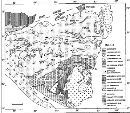
Chotanagpur Gneiss Complex (CGC)
What are the boundaries of the Chotanagpur Gneiss Complex (CGC)?
- South: Tamar-Poropahar (or South Purulia) shear zone (TPSZ) separating it from the North Singhbhum orogen north of the Singhbhum craton.
- North: Indo-Gangetic alluvium.
- East: Rajmahal Trap and Bengal Basin.
- West: Separated from the CITZ by the Mahanadi Gondwana graben.
What is the significance of the Chotanagpur Gneiss Complex (CGC) in the Satpura Mobile Belt?
The CGC, along with the CITZ, the eastern Aravalli craton (Mewar craton), and the Shillong (Meghalaya) Plateau of North East India, forms part of the composite Satpura Mobile Belt.

CITZ and CGC/NSO Comparison |
| CGC / NSO | CITZ |
| SNNF | SNNF |
| Mahakoshal | Mahakoshal |
| SNSF | SNSF |
| Makrohar granulite belt | Makrohar granulite belt |
| Bihar mica belt | Betul belt |
| Hesatu-Beibathan belt | Sulphide Mineralization |
| North Purulia shear zone | Tan shear zone |
| Hazaribagh-Dumka granulite belt | Ramakona-Katang granulite belt |
| Kinjhar, Gangpur, Ranchi Groups | Sauser Group |
| Gumla-Purulia granulite belt | Balaghat-Bhandara granulite belt |
| Tamar-poropahar shear zone | CISZ |
| Singhbhum Group | Sakoli (??) and Chilpi Groups |
| Singhbhum craton | Bastar craton |
Correlation of SMB
| Aravalli Craton | CITZ | Chhotanagpur Gneiss/NSO | NE India |
| Vindhyan | Vindhyan/Bijawar | Munger Group | Shillong Group |
| GBF | SNNF | SNNF | Brahmaputra Fault |
| Hindoli | Mahakoshal | Mahakoshal | |
| Jahazpur Thrust | SNSF | SNSF | |
| Mangalwar Complex and Bijawar Group | Amla Gneiss with Golihat Group | Bihar Mica belt | Gneiss with OMG Group |
| Rajpura-Dariba belt | Baragon and Bhopal’s Group | Hesatu-Beibathan belt | |
| Kaliguman shear zone | Tan shear zone | North Purulia shear zone | Shillong gneisses |
| Netravadla Complex | Ramakona-Katang granulite belt | Hazaribagh-Dumka granulite belt | |
| Keluiguman shear zone | Sauser Group | Kinjhar, Gangpur, Ranchi… | |
| Lunavada-Champaner-Delhi sequence | Balaghat-Bhandara granulite belt | Gumla-Purulia granulite belt | |
| Pilva-Chiwali Group | CISZ | Tamar-poropahar shear zone | Phanerozoic Dauki Fault |
| Aravalli belt on Mewar craton | Sakoli (??) and Chilpi Groups | Singhbhum Group on Singhbhum craton |
