CHow Clouds Form (The Process of Cloud Formation)
How Do Most Clouds Form?
Most clouds form as air rises, expands, and cools. The primary mechanisms responsible for cloud development include surface heating and free convection, topography, widespread ascent due to the convergence of surface air, and uplift along weather fronts. This process of cloud formation is integral to understanding weather patterns, including phenomena like rain showers and the development of nimbus clouds.
Surface Heating and Free Convection
What is Surface Heating and Free Convection?
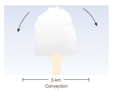
Surface heating and free convection occur when certain areas of the Earth’s surface heat up more quickly than others, causing the air in contact with these hot spots to become warmer and rise. This process can lead to the formation of cumulus clouds, which are a common type of cloud observed during fair weather. This process is also significant in the science of clouds and their behavior.
- Some areas absorb sunlight better, heating up quickly and increasing the temperature and humidity in the air.
- The air in contact with these hot spots warms up, causing a change in relative humidity.
- A thermal (a hot bubble of air) breaks away from the warm surface and rises, expanding and cooling as it ascends, approaching the dew point where condensation begins.
- Rising thermals mix with cooler, drier air, gradually losing their identity, affecting the cloud base and cloud formations.
- The upward movement of the thermal slows, but subsequent rising thermals may help it rise higher, contributing to the cloud formation process.
- If the rising air cools to its saturation point, moisture condenses, forming a cumulus cloud, a critical step in cloud development.
What Happens Outside a Cumulus Cloud?
- The air motions are downward outside the cumulus cloud, impacting cloud movement and weather conditions.
- Downward motions are caused by evaporation around the cloud’s outer edge, cooling the air and making it heavy, which can influence local weather and climate.
- Another reason for downward motion is the completion of the convection current started by the thermal, contributing to the cloud formation mechanism.
- Cool air slowly descends to replace the rising warm air, creating rising air in the cloud and sinking air around it, which is significant in understanding air pressure and cloud science.
- Subsiding air inhibits the growth of thermals beneath it, leading to significant blue sky between small cumulus clouds, highlighting the relationship between cloud formation and weather cloud predictors.
- As cumulus clouds grow, they shade the ground, cutting off surface heating and upward convection, a key factor in cloud temperature regulation.
- Without the continual supply of rising air, the cloud begins to erode as its droplets evaporate, influencing cloud composition and cloud movements.
- As the cloud dissipates or moves with the wind, surface heating regenerates another thermal, forming a new cumulus, contributing to the understanding of clouds and the water cycle.
- This cycle often causes cumulus clouds to form, disappear, and reform in the same spot, relevant to studying clouds and rain formation.
Tpography
How Does Topography Affect Cloud Formation?
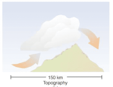
Topography affects cloud formation through orographic uplift, where horizontally moving air is forced to rise over a mountain, cooling and condensing to form orographic clouds. This process plays a role in the formation of different cloud types, including warm clouds and ice clouds, and is essential in cloud seeding processes.
- Horizontally moving air must go over large obstacles like mountains, causing orographic uplift, a phenomenon linked to cloud base forecast and cloud altitude studies.
- This lifting produces cooling, and if the air is humid, clouds form, known as orographic clouds, which are important in cloud forecasting and understanding cloud levels.
- On the downwind side of the mountain, the air is warmer than on the upwind side due to latent heat release during condensation and warming from the sinking process, which can affect cloud height and cloud wall formation.
- The dew point temperature on the downwind side is lower compared to the upwind side, a detail important in dew point calculation and understanding cloud formations.
- The leeward side of a mountain, where precipitation is low and the air is drier, is called a rain shadow, indicating very low water vapor content, and is relevant to the study of clouds after rain and cloud forecast accuracy.
- Lenticular clouds, lens-shaped, form by the movement of air over a mountain, contributing to the study of cloud formation in different climates and weather conditions.

How Do Lenticular Clouds Form?
- As moist air rises on the upwind side of the wave, it cools and condenses, producing a cloud, a critical part of understanding the science of clouds and their movements.
- The air sinks and warms on the downwind side, causing the cloud to evaporate, contributing to the formation of rain clouds and the understanding of cloud making processes.
- Lenticular clouds appear motionless from the ground as air rushes through them, which can be significant in studies related to cloud forecast and predicting cloud behavior.
- Lenticular clouds form one above the other when the air between cloud-forming layers is too dry to produce clouds, influencing cloud seeding and rain seeding processes.
- Lenticular clouds directly over the mountain are called mountain wave clouds, important in the study of cloud altitude and formation of clouds in varying weather patterns.
- Beneath the lenticular cloud, a large swirling eddy forms, with the rising part of the eddy possibly cooling enough to produce rotor clouds, a key element in understanding the cloud formation process.
Convergence of Surface Air
How Does the Convergence of Surface Air Lead to Cloud Formation?
When two surface air masses converge, the upward movement of air leads to cloud formation. This process is significant in understanding cloud phenomena, including the development of rain clouds and warm fronts, and plays a role in measuring humidity and temperature variations in cloud science.
- When two surface air masses converge, the upward movement of air forms clouds, contributing to cloud formation and predicting weather patterns like increasing clouds.
Forced Lifting Along Weather Fronts
How Does Uplift Along Weather Fronts Contribute to Cloud Formation?
Uplift along weather fronts occurs when two cold fronts move towards each other, forcing warm air to rise and form clouds. This process contributes to the formation of extensive cloud systems, influencing climate and weather, and is central to the science of clouds and cloud temperature studies.
When two cold fronts move towards each other, warm air rises, forming clouds, a process that is crucial to understanding the formation of weather clouds and the overall process of cloud formation.


💯💯👍
My site FQ7 covers a lot of topics about Thai-Massage and I thought we could greatly benefit from each other. Awesome posts by the way!
Your ideas absolutely shows this site could easily be one of the bests in its niche. Drop by my website UQ5 for some fresh takes about Cosmetics. Also, I look forward to your new updates.