What is the Chhattisgarh Basin?
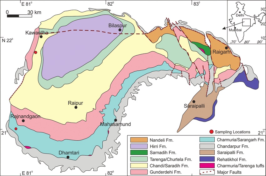
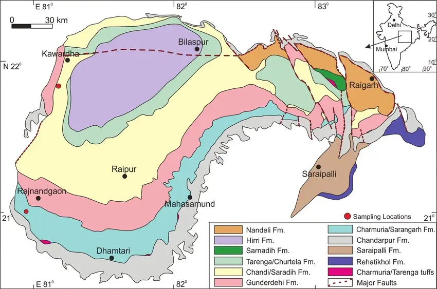
The Chhattisgarh basin is the largest Purana basin in the Bastar craton, covering approximately 36,000 sq. km. It is situated on the northern edge of the Bastar craton and is bounded by several geological features:
- West: Kotri-Dongargarh orogen
- North: Satpura mobile belt
- Northeast: Gondwana graben of Mahanadi
- Southeast: Eastern Ghats mobile belt
- South: Basement gneiss enclosing the Sona-khan greenstone belt
The basin is the third largest Purana basin after the Vindhyan and Cuddapah basins, extending about 300 km east-west and 200 km north-south with an irregular rectangular configuration.
What are the economic resources in the Chhattisgarh Basin?
The Chhattisgarh basin has vast limestone and dolomite resources, which are crucial for the Bhilai Steel Plant and nearby cement factories. Additionally, significant uranium mineralization areas are associated with the unconformity between the gneissic basement and the Chhattisgarh succession.
Notable Resources:
- Limestone and Dolomite: Feed the Bhilai Steel Plant and cement factories.
- Uranium Minerals: Pitchblende, betauranophane, autunite, breunnerite.
- Kimberlite Pipes: Recently discovered in the surrounding granitic terrain.
What evidence of ancient life is found in the Chhattisgarh Basin?
Stromatolites reported from the Chhattisgarh basin indicate a middle to upper Riphean age. Additionally, microbiota, mainly filamentous prokaryotic cyanobacteria and acritarchs, have been recorded. The Riphean sequence spans from 1.6 billion to 800 million years ago.
Lithostratigraphy of Chhattisgarh Supergroup
| Group | Formation (thickness in m) | Lithology |
|---|---|---|
| Raipur Group (1900 m) | Maniari Shale (70) | Purple shale, dolomite, gypsum |
| Hirri Dolomite (70) | Grey dolomite | |
| Tarenga Shale (80) | Dolomitic shale, shale-chert beds, purple shale | |
| Chandi Limestone (670) | Stromatolitic dolomite, limestone, glauconitic sandstone, shale | |
| Gunderdehi Shale (430) | Shale with limestone interbeds, arenite-shale, ignimbrite | |
| Charmuria Limestone (490) | Phosphatic limestone with shale interbeds, ferruginous limestone, phosphatic dolomite, chert-shale-pelite | |
| Bijepur Shale (100) | Green and brown calcareous shale with sandy interbeds | |
| Chandrapur Group (400 m) | Kansapathar Sandstone (200) | Glauconitic sandstone |
| Chaparthi Shale (70) | Shale with arenite interbeds | |
| Lodharhi Conglomerate (60) | Purple arkose, gritty arenite and basal conglomerate | |
| Singhora Group (400 m) | Chuipali Shale (300) | Shale with chert, limestone, dolomite, siltstone |
| Bhalukona Sandstone (20) | Sandstone, siltstone, minor shale | |
| Saraipali Shale (60) | Variegated shale with siltstone, limestone, porcelanite, felsic tuff | |
| Rehatikhol Conglomerate (20) | Feldspathic arenite, arkose and basalt conglomerate | |
| Nonconformity | ||
| Crystalline basement of Bastar craton | ||
Smaller Basins in the Bastar Craton
Khariar Basin
Characteristics:
- Shape: Irregular, oval-shaped basin
- Location: Nawagarh-Khariar plateau
- Area: 1500 sq. km
- Sediments: Pairi Group (600-1000m thick)
- Age: Lower to Upper Riphean (1.6 billion – 800 million years)
- Alternate Name: Nawagarh basin
Lithostratigraphy of Khariar Basin
| Group | Thickness (m) | |
| Ling Dongri Sandstone | 60-120 | |
| Tarjhar Shale | 205 | |
| Gaighat Sandstone | 150-300 | |
| Disconformity | ||
| Neor Sandstone | 40-160 | |
| Kulharighat Limestone | 80-120 | |
| Devdhara Sandstone | 10-80 | |
| Unconformity | ||
| Crystallines of Bastar Craton | ||
Ampani Basin
Characteristics:
- Location: Small plateau south of Khariar near Ampani
- Area: 220 sq. km
- Sediments: 280m thick sandstone-shale sequence
- Features: Domed around hornblend granodiorite at Khaligarh, thought to be intrusive
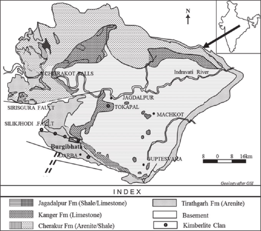
Indravati Basin
Characteristics:
- Shape: Irregular rhomboid
- Area: 900 sq. km
- Sediments: Orthoquartzite-shale-carbonate sequence (~500m thick)
- Economic Minerals: Cement grade limestone, dolomite
- Features: Recently located kimberlite bodies around Tokapal
Stratigraphy of Indravati Basin
| Formation | Thickness (m) | Description |
| Jagdalpur Formation | 200-250 | Purple shale with stromatolitic dolomite |
| Kanger Limestone | 50-200 | Purple limestone and laminated shale |
| Cherakur Formation | 50-60 | Purple shale and siltstone with interbeds of arkosic sandstone, chert pebble conglomerate, and ‘grit’ |
| Tiratgarh Formation | 50-60 | Quartz arenite with minor laminated shale, subarkose, and quartz pebble conglomerate |
Sabari Basin
Characteristics:
- Shape: Triangular
- Location: Near Sukma, named after the Sabari River
- Area: 700 sq. km
- Geology: Basal conglomerate, quartzite, limestone, purple to grey shale
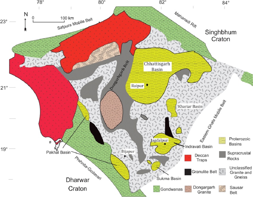
Correlation of Basins in Bastar Craton
The broad lithostratigraphic correlation of the various Purana basins of Chhattisgarh State, excluding the Palaeoproterozoic Abujhmar basin, is given below:
| Chhattisgarh | Khariar | Ampani | Indravati | Sabari | |
| Raipur Gp | Jagdalpur Sh | Sabari Gp (Upper) | |||
| Chandrapur Gp | Pairi Gp | Ampani Gp | Cherakur Fm | Sabari Gp (Lower) | |
| Singhora Gp | Tirtagarh Sst |
Pranhita-Godavari Basin
What is the Pranhita-Godavari Basin?
The Pranhita-Godavari (P-G) basin occurs in two parallel NW-SE trending sub-basins at the junction of the Dharwar and Bastar cratons. It extends for about 400 km in length and 100 km in width, with a significant section of Gondwana sediments in the middle separating the two sub-basins.
Key Features:
- Sediment Thickness: Approximately 6000m
- Outliers:
- Sharnala (links with Cuddapah basin)
- Kadam (branches from Pakhal sub-basin)
- Lohara (near Chandrapur)
- Inliers:
- Mailaram (south)
- Chinnur group (middle)
- Chandarpur (north)
- Resources: Limestone, dolomite, building stones, minor marble, barite, iron stone
Geological Context:
The Pakhal belt rests unconformably on the Archaean Dharwar craton, and the Albaka belt has a tectonic contact with the Bastar craton.
Pranhita-Godavari Basin Geological Map
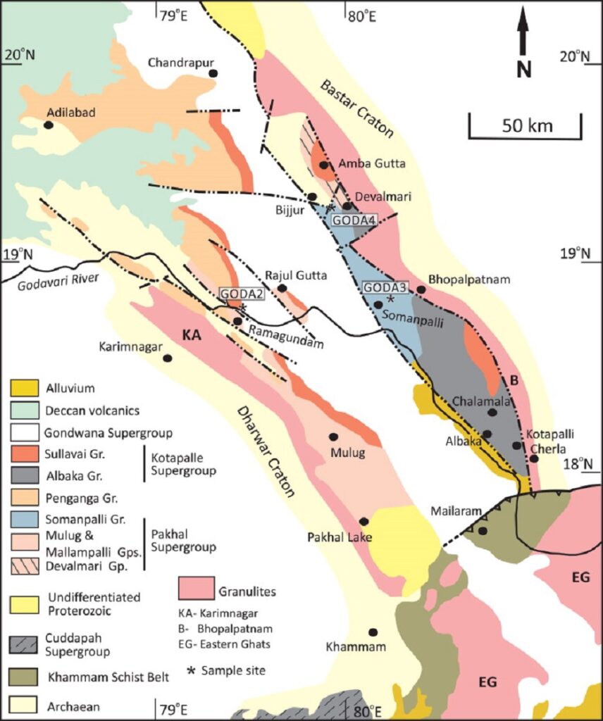
An Inlier is an area of older rocks surrounded by younger rocks. Inliers are typically formed by the erosion of overlying younger rocks to reveal a limited exposure of the older underlying rocks. An outlier is an area of younger rock completely surrounded by older rocks.
An outlier is typically formed when sufficient erosion of surrounding rocks has taken place to sever the younger rock’s original continuity with a larger mass of the same younger rocks nearby.
Disclaimer
The content provided on studyhub.net.in is intended for informational and educational purposes, designed to support students and professionals preparing for competitive exams, including UPSC GSI, CSIR NET, GATE Geology and Geophysics, and GATE 2025. All articles, study guides, and materials are carefully curated from highly recommended books and reputable sources to serve as an additional resource for students preparing for these exams.
While we strive to ensure accuracy and reliability, users are advised to verify information and use it in conjunction with other resources. This website provides resources and insights aligned with preparation for geology, geophysics, earth sciences, environmental studies, geoscientific research, petroleum geology, and related fields.
If any content is found to infringe on copyright, please reach out to us at pdpal9@gmail.com. We are committed to respecting intellectual property rights and will address any issues promptly.
Thank you for choosing studyhub.net.in as part of your educational journey.
Best map with content ❤️👍🙏
It appears that you know a lot about this topic. I expect to learn more from your upcoming updates. Of course, you are very much welcomed to my website Article Sphere about SEO.
You rocked this subject and have astounding insights. I also work hard in putting together great content about Outsourcing, feel free to visit QN9
This is some awesome thinking. Would you be interested to learn more? Come to see my website at YH6 for content about Article Marketing.
Great site with quality based content. You’ve done a remarkable job in discussing. Check out my website QH6 about Car Purchase and I look forward to seeing more of your great posts.