Chapter Overview
- The study of bathymetry determines ocean depths and ocean floor topography.
- Echo sounding and satellites are efficient bathymetric tools.
- Most ocean floor features are generated by plate tectonic processes.
- Different sea floor features exist in different oceanographic locations.
Bathymetry
- Measures the vertical distance from the ocean surface to mountains, valleys, plains, and other sea floor features
Measuring Bathymetry
- Soundings
– Poseidonus made first sounding in 85 B.C.
– Line with heavy weight
– Sounding lines used for 2000 years - Fathom
– Unit of measure
– 1.8 meters (6 feet) - HMS Challenger
– Made first systematic measurements in 1872 - Deep ocean floor has relief
– Variations in sea floor depth - Echo Soundings
– Echo sounder or fathometer
– Reflection of sound signals
– German ship Meteor identified mid-Atlantic
ridge in 1925 - Lacks detail
- May provide inaccurate view of sea floor
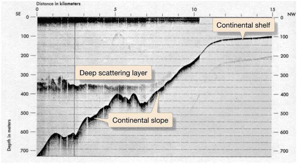
- Precision Depth Recorder (PDR)
– 1950s
– Focused high-frequency sound beam
– First reliable sea floor maps produced
– Helped confirm sea floor spreading
Modern Bathymetry Measuring
- Multibeam Echo
Sounders
– Multiple simultaneous sound frequencies - Seabeam
– First multibeam echo sounder
– Map sea floor strips up to 60 km (37 mi) wide - Sonar
– Sound navigation and ranging acronym - Side scan sonar
– GLORIA (Geological Long-range Inclined Acoustical instrument)
– Sea MARC (Sea Mapping and Remote Characterization) - Can be towed behind ship to provide very detailed bathymetric strip map
GLORIA Side Scanning Sonar

Sea Floor Mapping from Space
- Uses satellite measurements
- Measures sea floor features based on gravitational bulges in sea surface
- Indirectly reveals bathymetry


- Satellite-derived cean surface gravity
- Reveals bathymetry where ships have not conducted research
Seismic Reflection Profiles
- Air guns
- Strong, low-frequency sounds
- Details ocean structure beneath sea floor


Hypsographic Curve
- Shows relationship between height of land and depth of ocean
- 70.8% of Earth covered by oceans
- Average ocean depth is 3729 meters
- Average land elevation is 840 meters
- Uneven distribution of areas of different depths/elevations
- Variations suggest plate tectonics at work

Ocean Provinces
- Three Major Provinces
- Continental margins
–Shallow-water areas close to shore - Deep-ocean basins
– Deep-water areas farther from land - Mid-ocean ridge
–Submarine mountain range

Continental Margins
- Passive
– Not close to any plate boundary
– No major tectonic activity
– East coast of United States - Active
– Associated with convergent or transform plate boundaries
– Much tectonic activity

Active Continental Margins
- Convergent Active Margin
– Oceanic-continent convergent plate boundaries
– Active continental volcanoes
– Narrow shelf
– Offshore trench
– Western South America
- Transform Continental Margin
– Less common
– Transform plate boundaries
– Linear islands, banks, and deep basins close
to shore
– Coastal California along San Andreas Fault
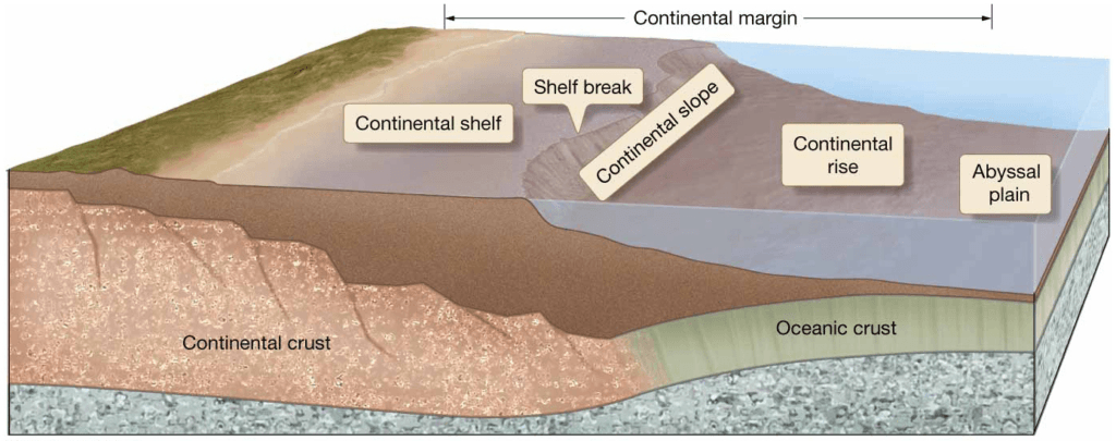
Continental Margin Features
- Continental shelf
- Shelf break
- Continental slope
- Continental rise
Continental Shelf
- Flat zone from shore to shelf break
– Shelf break is where marked increase in slope angle occurs. - Geologically part of continent
- Average width is 70 km (43 miles) but can extend to 1500 km (930 miles)
- Average depth of shelf break is 135 meters (443 feet).
- Type of continental margin determines shelf features.
- Passive margins have wider shelves.
- California’s transform active margin has a continental borderland.

Continental Slope
- Where deep ocean basins begin
- Topography similar to land mountain ranges
- Greater slope than continental shelf
– Averages 4° but varies from 1–25° gradient - Marked by submarine canyons
Submarine Canyons
- Narrow, deep, V-shaped in profile
- Steep to overhanging walls
- Extend to base of continental slope, 3500 meters (11,500 feet) below sea level
- Carved by turbidity currents
Turbidity Currents
- Underwater avalanches mixed with rocks and other debris
- Sediment from continental shelf
- Moves under influence of gravity
- Sediments deposited at slope base

Continental Rise
- Transition between continental crust and oceanic crust
- Marked by turbidite deposits from turbidity currents
- Graded bedding in turbidite deposits
- Deposits generate deepsea fans, or submarine fans
- Distal ends of submarine fans become flat abyssal plains


Abyssal Plains
- Extend from base of continental rise
- Some of the deepest, flattest parts of Earth
- Suspension settling of very fine particles
- Sediments cover ocean crust irregularities
- Well-developed in Atlantic and Indian oceans
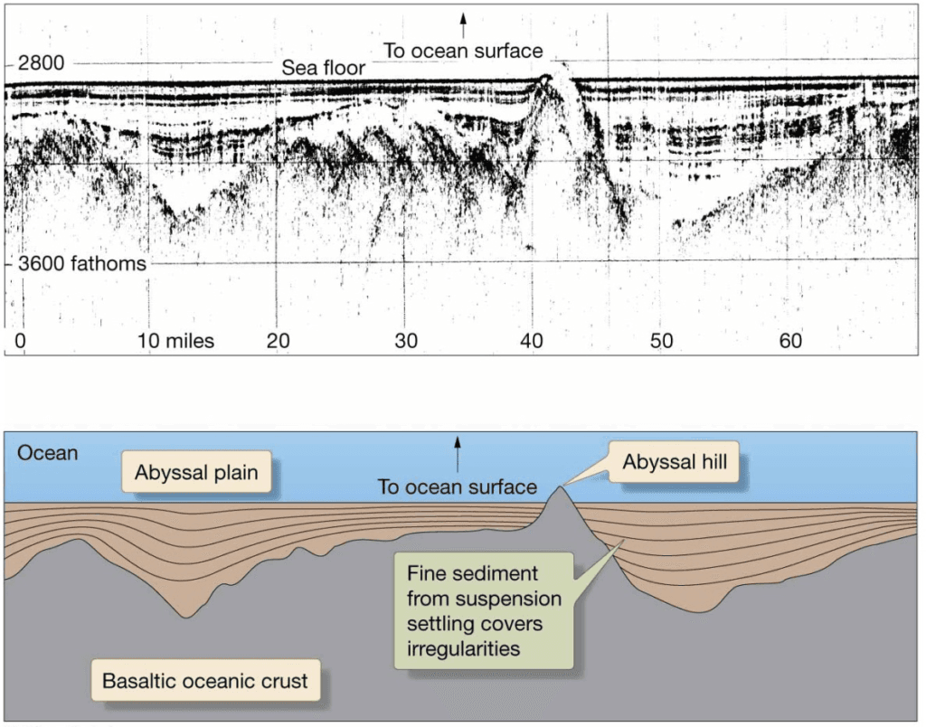
Abyssal Plain Volcanic Peaks
- Poke through sediment cover
- Below sea level:
– Seamounts, tablemounts, or guyots at least
1 km (0.6 mile) above sea floor
– Abyssal hills or seaknolls are less
than 1 km (0.6 mile) above sea floor - Above sea level:
– Volcanic islands
Ocean Trenches and Volcanic Arcs
- Convergent margins generate ocean
trenches.
– Deepest part of oceans
– Most in Pacific Ocean
– Deepest trench – Mariana Trench at
11,022 meters (36,161 feet)

Island and Continental Arcs
- Volcanic arc on nonsubducted ocean plate
- Island arc
– Islands in ocean
– Japan - Continental arc
– Mountains on land
– Andes Mountains

Pacific Ring of Fire
- Margins of Pacific Ocean
- Majority of world’s active volcanoes and
earthquakes - Marked by convergent boundaries
Mid-Ocean Ridge
- Longest mountain chain
- On average, 2.5 km (1.5 miles) above
surrounding sea floor - Volcanic
- Basaltic lava
- Divergent plate boundary

Mid-Ocean Ridge Features
- Rift Valley
– Downdropped area on crest of ridge
– Marked by fissures and faults
– Small earthquakes - Seamounts – tall volcanoes
- Pillow lava or pillow basalt – shapes formed when hot basaltic lava quickly cools
- Hydrothermal Vents
- Sea floor hot springs
- Foster unusual deep-ocean ecosystems able to survive without sunlight
Hydrothermal Vents
- Warm water vents – temperatures below 30°C (86°F)
- White smokers – temperatures from 30–350°C (86–662°F)
- Black smokers – temperatures above 350°C (662°F)

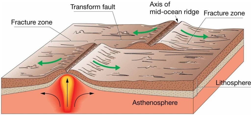
Fracture Zones and Transform Faults
- Transform faults along mid-ocean ridge offset spreading zones.
– Linear ridge on spherical Earth
– Seismically active - Fracture zones along Pacific Ocean midocean rise
– Seismically inactive
– Occur beyond offset fragments of rise

Comparison Between Transform Faults and Fracture Zones

Fracture Zones and Transform Faults
Oceanic Islands
- Volcanic activity
- Hotspots
- Island arcs
- Islands that are part of continents
Reference: All images and content are taken from Essentials of Oceanography by Alan P. Trujillo and Harold V. Thurman, 12th Edition.